


La Clusaz, pointe de Beauregard, La Clusaz

chuck
User
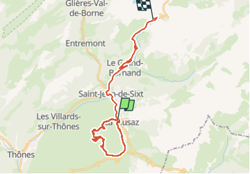

Length
28 km

Max alt
1632 m

Uphill gradient
1151 m
Km-Effort
42 km

Min alt
887 m

Downhill gradient
856 m
Boucle
No
Creation date :
2025-07-29 07:14:05.673
Updated on :
2025-07-29 14:27:34.534
6h38
Difficulty : Easy

FREE GPS app for hiking
 SityTrail
IGN / Geographical institutes
SityTrail Plus
The world is yours!
About
Trail Walking of 28 km to be discovered at Auvergne-Rhône-Alpes, Upper Savoy, La Clusaz. This trail is proposed by chuck.
Photos

Positioning
Country:
France
Region :
Auvergne-Rhône-Alpes
Department/Province :
Upper Savoy
Municipality :
La Clusaz
Location:
Unknown
Start:(Dec)
Start:(UTM)
299925 ; 5086852 (32T) N.
Comments